Haidian Minds Converge · Jing-Zhang Stars Aglow: Tiangong Star Atlas AI Civic Living Room
Rooted in Haidian's innovation culture and the century-old Jing-Zhang legacy, Tianwen, Nuwa, and Yinglong organize an explainable, participatory, and climate-aware AI civic living room.
Haidian Minds Converge · Jing-Zhang Stars Aglow: Tiangong Star Atlas AI Civic Living Room
v1.2 review thesis: Tiangong Civic Protocol. Every AI service entering public space passes six gates: question register, data permission, spatial capacity, human takeover, 90-day review, and renewal/exit. This does not add statutory planning; it translates Tianwen, Nuwa, and Yinglong into explainable, participatory, pausable, and reversible delivery discipline. Source Depth
Design Proposition and Data Boundary
The proposal translates the Jing-Zhang Railway's legacy of mobility and innovation into civic innovation infrastructure for the next century. AI should become understandable, optional, and correctable in streets, communities, and parks, rather than remain confined to laboratories. The core structure stays unchanged: three corridors, three cores, two wings, and one loop. Tianwen stands for inquiry and explainability, Nuwa for connection and co-governance, and Yinglong for water-sensitive resilience. Source Source
The repository currently contains no verifiable official GIS/CAD redlines, regulatory controls, ownership, existing-building inventory, utility capacity, ecology, or heritage vector data. The approximately 11.4 sq km boundary and three key areas come from the organizer-provided provisional_boundaries.geojson. They support concept composition, task allocation, and local checks only, not statutory boundaries, precise area claims, demolition decisions, or engineering commitments. Source Spatial data Standard
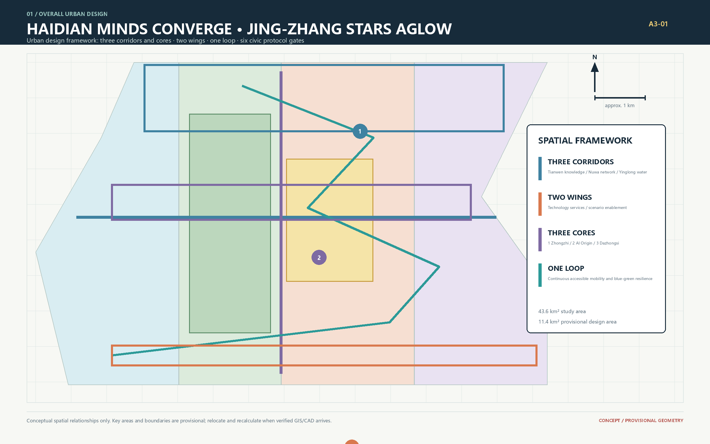
Three Scales and Regional Collaboration
The approximately 43.6 sq km research scope connects northern Haidian innovation resources, the Jing-Zhang corridor, and everyday services. The provisional 11.4 sq km overall design scope organizes the three-corridor network. The three key areas host near-term spatial prototypes that can be tested, assessed, and withdrawn. Metric Metric
Regional collaboration uses explicit complementary interfaces: model evaluation, talent services, and civic issues connect to Zhongguancun and Beiwei Community; research-validation briefs connect to Future Science City and Huairou Science City; pilot production and commercialization services connect to Beijing E-Town; and cross-regional urban challenges reach the Beijing-Tianjin-Hebei network. Each relationship starts with a public brief, short residency, or joint evaluation, and expands only after responsibilities, budgets, and data agreements are confirmed.
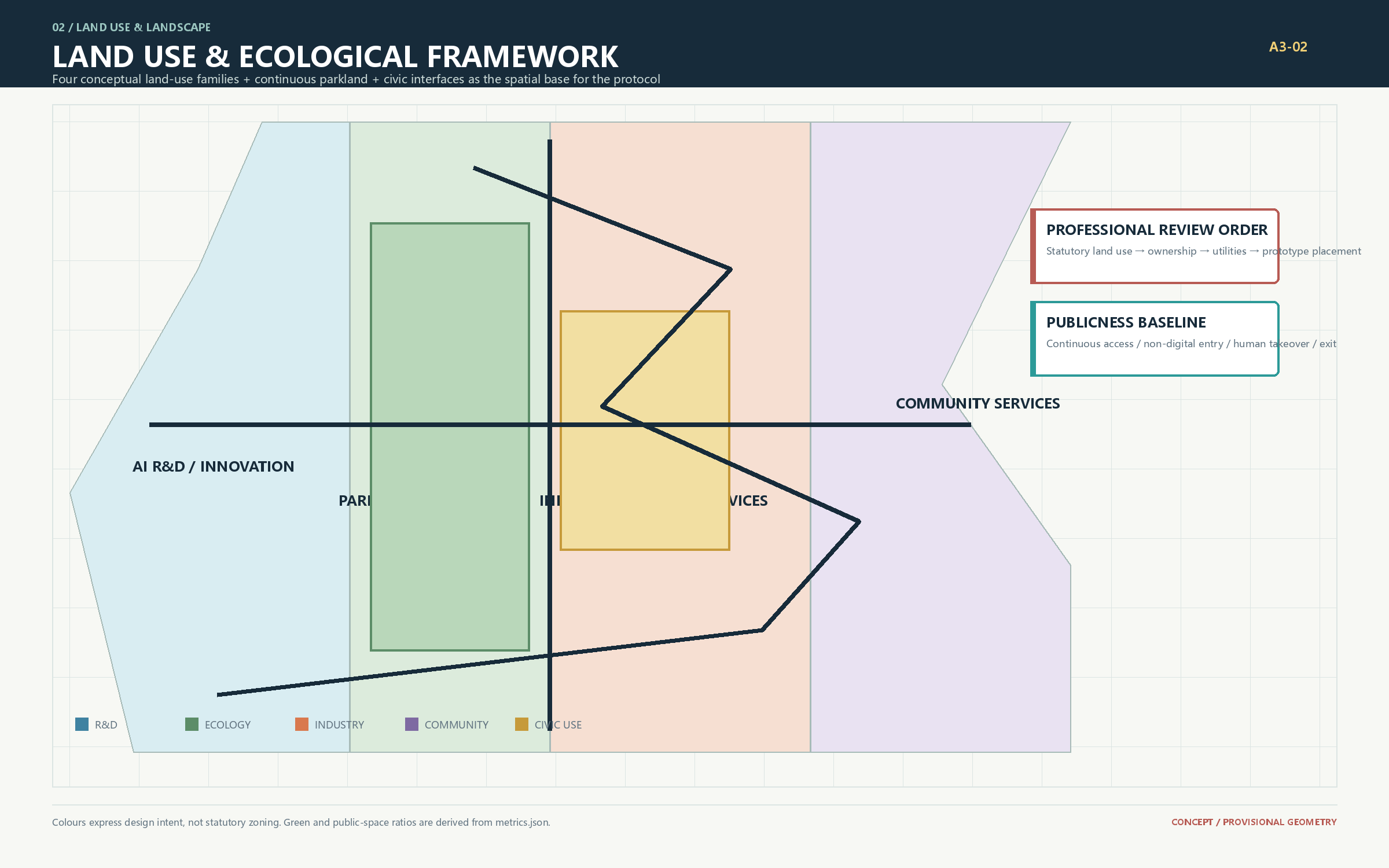
Tiangong Star Atlas: Three Corridors, Three Cores
The Tianwen Knowledge Corridor combines explainable wayfinding, Jing-Zhang memory, open research, and multilingual communication. The Nuwa Weaving Corridor connects residents, researchers, and service staff through civic tables, trusted-data collaboration, and human review. The Yinglong Water-Vein Corridor combines rain gardens, shade, microclimate notices, and slow mobility as tangible resilience infrastructure. They connect the Zhongzhiyuan R&D accelerator, AI Origin civic incubator, and Dazhongsi industry-experience core, supported by the Zhongguancun service wing, Xiaoyue River scenario wing, and a continuous slow-mobility loop. Depth
Five functions form one loop: original research generates questions and models; validation and transfer provides controlled testing; talent community supports living and exchange; public experience builds understanding and trust; urban resilience applies technology to real conditions. The identity system uses a Jing-Zhang trajectory as warp, Haidian innovation nodes as weft, and three core stars as markers. Its wordmarks are “天工星图” and “TIANGONG STAR ATLAS,” with no copied institutional marks, character imagery, or unlicensed typefaces.
Global references are mechanisms, not forms to copy: Kendall Square's academic-industry public interface, Station F's integrated startup service, Vector Institute's open research network, the Alan Turing Institute's interdisciplinary collaboration, Barcelona Supercomputing Center's public science communication, Seoul Digital Media City's scenario integration, reversible civic prototypes, and open-source maintainer communities. Their local translations are shared ground floors, staffed service desks, an annual challenge list, four-party governance, explainable galleries, controlled test streets, 90-day pilots, and a contribution wall. Local regulation, operating cost, and public impact must be reviewed before adoption. Spatial data
Eight-resource ecosystem map and civic protocol
Land, space, industry, capital, talent, compute, data, and scenarios form one staged-access loop. The Zhongguancun Technology Services Wing brings resources in; Zhongzhiyuan frames questions and tests models; AI Origin translates them into public services; Dazhongsi completes product and cultural exchange; the Xiaoyue River wing carries validated scenarios into everyday use. Every transfer carries an accountable owner, data permission, and an exit condition. Capital, procurement, and policy are conceptual mechanisms, not confirmed commitments. Spatial data Spatial data
| Resource | Spatial interface | Release evidence | Fallback |
|---|---|---|---|
| Land and space | Three corridors, three cores, two wings, one loop | official base, ownership and capacity review | move or reduce prototype |
| Industry and talent | Tianwen Test Port and service wing | public question, residency, researcher sign-off | pause test, keep human service |
| Compute and data | controlled test loop and data workshop | licensed/synthetic catalogue, load monitoring | downgrade to offline demo |
| Scenario and public value | Nuwa civic room and Yinglong interface | feedback, human review, 90-day report | exit and publish reason |
Overall Urban Design and Renewal
Three future-street prototypes bring the structure to the ground. Tianwen Star-Rail Street organizes booked low-speed shuttles, walking, cycling, flexible curbs, and low-glare guidance. Nuwa Weave Street combines permeable tree pits, demountable civic tables, accessible micromobility, and quiet-priority crossings. Yinglong Water-Mirror Loop links shallow rain gardens, shade, and switchable water-level notices. Spatial data Spatial data Spatial data
Four replaceable building prototypes translate the idea into civic interfaces: Tianwen Cloud Terrace links research, model evaluation, and a public gallery; Nuwa Weave Nest organizes live-work studios and repair spaces around a shared court; Yinglong Water Court uses a lifted public floor, rain garden, and deep eaves; Star Atlas Interface combines accessible transfer, public service, and changing exhibitions. Spatial data Metric
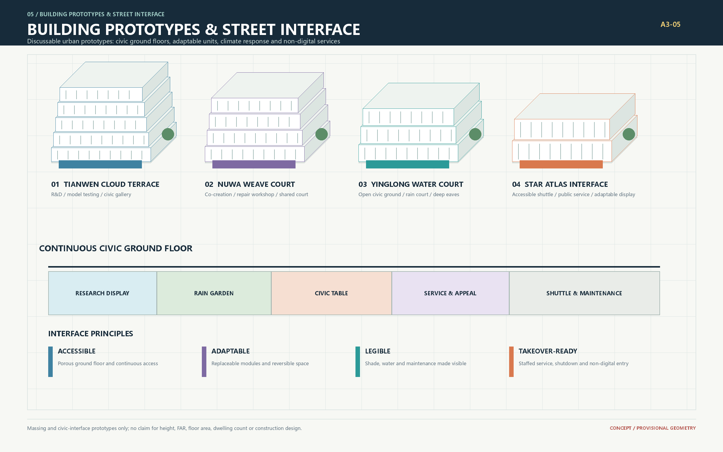
Renewal follows “inventory before intervention.” Once building age, structure, ownership, use, and historic value are verified, professional teams can classify maintenance, program infill, energy retrofit, interface opening, and conditional replacement. Until then, the proposal makes no parcel-level claim about demolition, floor-area ratio, height, or development quantity. Depth
Action Briefs for Three Key Areas
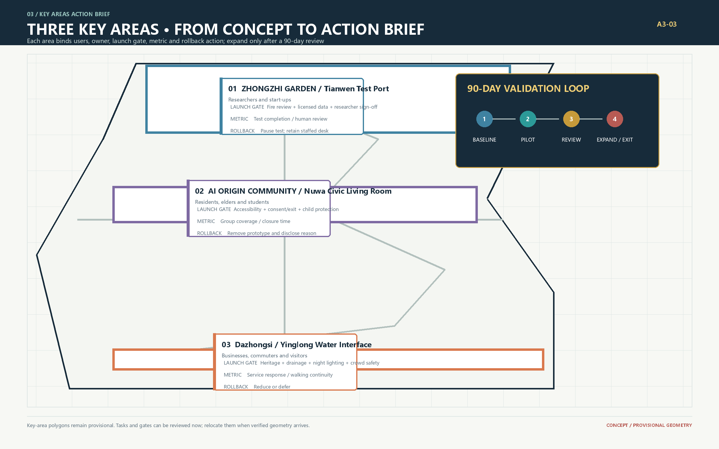
The provisional polygons are not formal parcels, but they can carry explicit program tasks, accountable roles, gates, and indicators. Once official data arrives, teams must run spatial conflict checks and relocate each task to a suitable parcel. A conflict with redlines, heritage, ownership, or capacity means moving, reducing, or cancelling the prototype, never altering official geometry to fit the concept. Spatial data
| Area / role | First spatial prototype and users | Lead and partners | Launch gate | Suggested indicators |
|---|---|---|---|---|
| Zhongzhiyuan / Tianwen Test Port | Bookable model-evaluation bench, edge demonstration, quiet knowledge garden; researchers, startups, students | Park operator; research institutes, enterprise safety, public-culture teams | Fire and load review; synthetic or licensed data only; researcher signs conclusions | Quarterly public briefs, test completion, human-review coverage, reused outcomes |
| AI Origin / Nuwa Civic Weave | Civic issue workshop, AI-literacy exhibit, demountable public table; residents, older adults, young people, local staff | Community operator; resident representatives, schools, data steward | Accessibility audit; informed consent and exit; teacher/guardian system for minors | Participant diversity, accessibility issue closure, response time, effective opt-out |
| Dazhongsi / Yinglong Urban Interface | Product validation, enterprise service, Jing-Zhang culture, rainwater and low-carbon mobility display; firms, commuters, visitors | District operator; industry service, heritage, mobility, landscape teams | Heritage, drainage, night-light, and crowd-safety review | Service response, walking continuity, rain-garden uptime, interpretation corrections |
The three first pilots are a model-evaluation sandbox, civic co-creation table, and climate-aware walking segment. Each runs for 90 days and produces a baseline, operations log, public feedback record, human-review record, and exit report. A pilot that fails safety, inclusion, or maintenance gates cannot become permanent.
AI Ecosystem, Personas, and Scenarios
The proposal serves algorithm researchers, startup product teams, residents and older adults, visiting students, public-service staff, accessible-mobility users, and international developers. Six explicit personas bind needs, space, non-digital access, and measurement, rather than treating “the public” as one abstract user group. Every scenario follows minimum necessary data, plain-language notice, opt-out, human takeover, and appeal. Spatial data
| Persona | Need | Spatial and non-digital access | Measure |
|---|---|---|---|
| Researchers and model engineers | safe evaluation and explainable evidence | Zhongzhiyuan; staffed booking desk | review coverage and public questions |
| Startups and industry services | validation, compliance and translation | service wing-Dazhongsi; human window | closed validation cases |
| Residents, older and low-digital-literacy people | understandable service and exit | AI Origin; paper and staffed route | diversity and opt-out success |
| Children, students and teachers | safe learning and cultural context | memory corridor; teacher-led route | safeguards and learning feedback |
| Commuters, accessible-mobility users | continuous accessible movement | Water-Mirror Loop; staffed help points | continuity and uptime |
| International visitors and developers | multilingual context and contribution | Dazhongsi interface; printed guide | reuse and correction closure |
| Scenario | Spatial host | Human and data boundary |
|---|---|---|
| Model evaluation sandbox | Zhongzhiyuan lab bench | Synthetic/licensed data; researcher review |
| Edge collaboration trial | Zhongzhiyuan test loop | No identity capture; on-site stop control |
| Trusted-data collaboration | AI Origin data workshop | Authorized catalog; steward audit |
| Accessible Tianwen guide | Knowledge Corridor | Temporary preference; user confirms route |
| Nuwa civic co-creation | Community table | Anonymous input; facilitator review |
| Learning companion | Experience corridor | Teacher in loop; child safeguards |
| Health information guide | Community service point | No diagnosis; professional referral |
| Multilingual Star Atlas story | Jing-Zhang interpretation point | Historical review; open correction route |
| Mobility suggestion | Water-Mirror Loop | No enforcement; user choice |
| Startup compliance assistant | Technology service wing | Legal review; not legal advice |
The first three are controlled industrial validation settings. The others translate technical capability into public value instead of substituting screens and sensors for spatial design. Metric
Mobility, Blue-Green Network, and Public Realm
Network priority is walking and wheelchairs, cycling, booked low-speed shuttles, maintenance, then emergency access. Flexible curbs can switch among pickup, logistics, rain-garden pause, and events by time, while keeping a continuous accessible path. Computing, energy, communications, drainage, and fire safety use a “maintainable interface + aggregate load monitoring + staged professional review” approach without presuming capacity. Depth
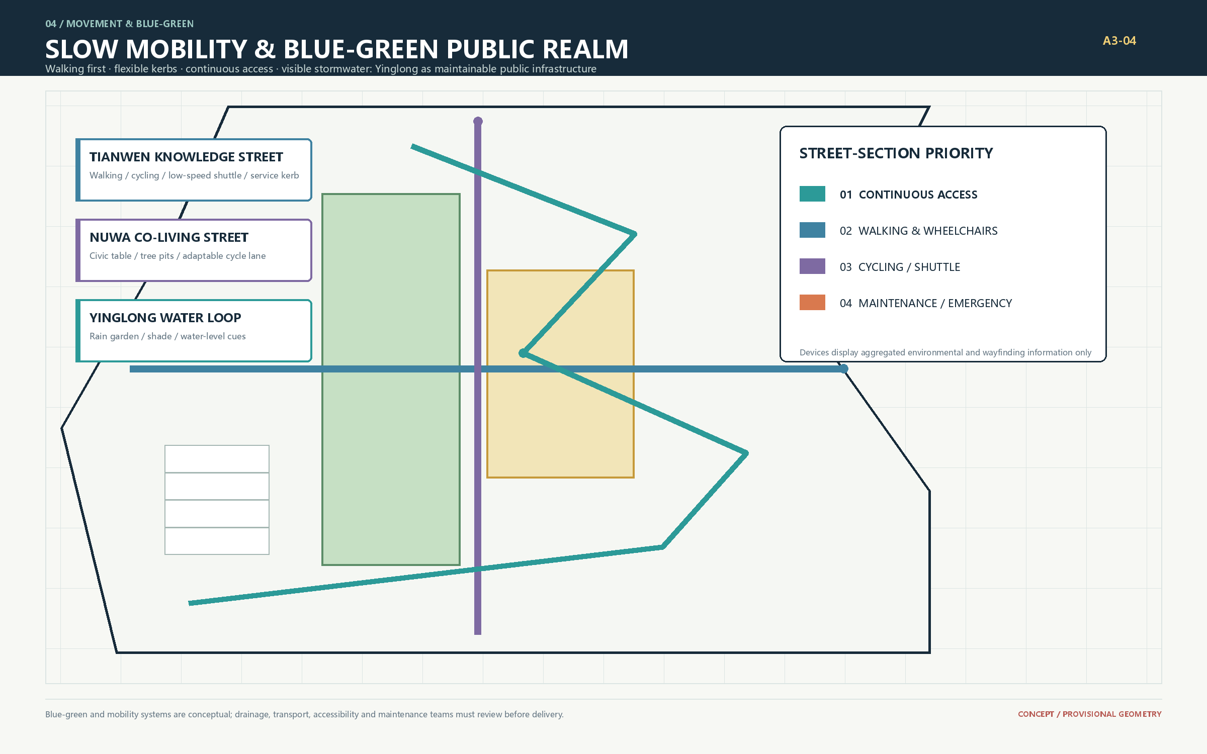
The Jing-Zhang Memory Corridor uses a verified railway timeline; Tianwen uses low-glare, switchable star-atlas guidance; Yinglong lets rain storage, shade, and civic activity share space. Three landmarks are conceptual programming components: Tiangong Cloud Terrace hosts explainable-AI exhibits, Nuwa Weaving Table hosts civic collaboration, and Yinglong Water-Vein Platform hosts multilingual culture and climate experience. A fourth Star Atlas Contribution Wall records human-reviewed public versions without promising selection or permanent construction. Spatial data Spatial data
Public-space components, honor display, and cultural narrative
Six replaceable components make the protocol legible without relying on a giant screen: a protocol plaque shows purpose, owner, data boundary, and expiry; a demountable table hosts co-creation; a staffed desk provides non-digital access and appeal; low-glare star guidance joins history and scenario; a rain-sensing node makes water and maintenance visible; and a contribution archive stores reviewed open outputs. Spatial data
East-west stitching uses demountable tables, accessible crossings, and low-glare guidance; north-south continuity uses the memory corridor, three-core entrances, and the Water-Mirror Loop. The three pilgrimage landmarks are not entertainment objects: each offers a reason to visit by explaining one technology, joining one collaboration, or witnessing one climate feedback. The wall displays only public, licensed, and human-reviewed versions. Depth
The cultural story has three acts: “the switchback rail” for engineering judgment and public responsibility; “the open atlas” for Zhongguancun research, startups, and open collaboration; and “the reversible city” for preserving choice after AI enters everyday life. The guidance language uses trajectory, latitude-longitude, three stars, and water-level marks as abstract symbols; it does not imitate historic fabric or use portraits. International line: “Every AI service entering the city leaves public evidence that can be explained, joined, paused, and exited.” Spatial data Source
Minimum inclusion gates are a continuous accessible route, seating and shade, low glare and quiet hours, non-digital access for children and older adults, multilingual and large-print information, and staffed service without a smartphone. Public access must never depend on identification, scoring, or profiling.
Phasing, Accountability, and Long-Term Operation
| Stage | Lead / partners | Deliverables | Gate to next stage |
|---|---|---|---|
| 0-6 months: verify | Organizer / planning, ownership, mobility, utilities, heritage | Official base data, site audit, conflict register, public baseline | Source, coordinates, license, and professional opinions verified |
| 6-18 months: prototype | Three area operators / community, research, design teams | Three 90-day pilots, accessibility audit, ethics and maintenance manuals | Safety incidents closed; review and exit mechanisms work |
| 18-36 months: connect | Renewal delivery body / mobility, landscape, industry services | Continuous corridor segments, shared interfaces, annual evaluation | Funding, maintenance, public benefit, and capacity approved |
| After year 3: iterate | Four-party forum / independent evaluator | Annual challenge list, residencies, international exchange, public report | Evidence determines expansion, adjustment, or exit each year |
Long-term operation uses a four-party forum of developer community, resident representatives, professional advisers, and data governance. It publishes quarterly problem and incident logs, and annual maintenance cost, public use, scenario performance, and retired projects. Procurement, events, and technology partners follow transparent rules. Spatial data
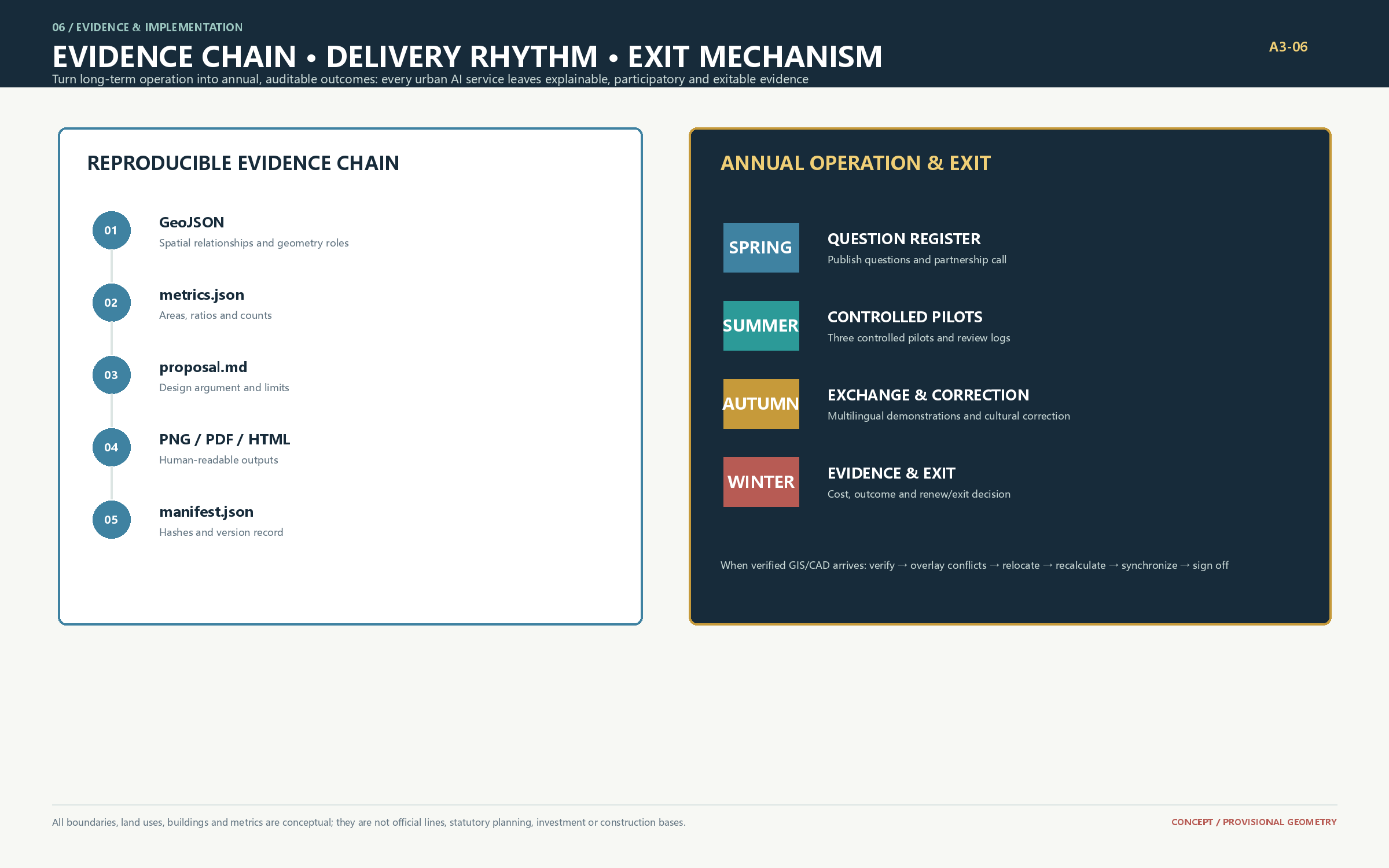
Four-season annual operating calendar
| Season | Proposed activity | Spatial host | Public output | Suggested lead |
|---|---|---|---|---|
| Spring | Jing-Zhang memory and city challenge register | memory corridor | public questions and partner calls | heritage editor + forum |
| Summer | developer residency and scenario-access week | Zhongzhiyuan-Xiaoyue River | three controlled prototypes and review logs | park operator + developer community |
| Autumn | AI Civic Living Room international exchange season | AI Origin-Dazhongsi | multilingual demonstrations and corrections | community and district operators |
| Winter | annual evidence and exit day | Star Atlas Contribution Wall | maintenance cost, public benefit, renew/exit record | independent evaluator + public forum |
Event brands, partners, budgets, procurement and international exchange remain conceptual recommendations. The calendar turns “long-term operation” into inspectable annual outputs rather than a promise that events will occur. Spatial data Depth
Metrics, Replacement Protocol, and Compliance
The package records provisional site area, prototype building footprint, green ratio, public-space ratio, and key-area count. Structured layers make them reproducible, but missing official geometry limits area and ratio values to internal consistency checks. Metric Metric Metric Metric
When official GIS/CAD arrives, the replacement order is: verify source and coordinate system; preserve a read-only original; overlay boundaries, roads, ownership, heritage, ecology, and utilities; relocate key-area tasks; recalculate every area and ratio; update GeoJSON, metrics, narratives, figures, PDFs, HTML, matrices, and manifest hashes together; obtain planning, mobility, utilities, architecture, accessibility, fire, and other required professional sign-off. Until every step is complete, the package remains conceptual. Source
Risks, Copyright, and Open Boundary
Main risks are relocation after boundary replacement, ownership or heritage constraints, utility capacity, algorithmic error, digital exclusion, and failed long-term maintenance. Responses are movable prototypes, early professional review, capacity gates, human takeover, non-digital service, and annual exit evaluation. See report/copyright_statement.md for sources, generation methods, and personal-data limits. This proposal is not government approval, investment commitment, or a construction basis. Source Spatial data
References
1. Beijing Municipal Commission of Planning and Natural Resources, public call for the Centennial Jing-Zhang AI Innovation Belt, 2026. 2. Project site package, brief/site-package/, 2026. 3. Agent Taskbook for the open urban-design call, 2026. 4. Local reference snapshot of the Ministry of Housing and Urban-Rural Development's Measures for the Administration of Urban Design.